

“As we got on the boat, sunlight brightened the sky, coloring the clouds a soft pastel pink.
Most of the researchers on the 67-foot catamaran called The Fulmar appeared tired yet focused, putting away their things, preparing the space for the day out at sea. Some were making tea, beginning to have breakfast or napping in a quiet corner before the work really began.
I and the other journalists sat at the table, waiting for instructions and talking with researchers who had joined us.
Jaime Jahncke, San Francisco State University adjunct professor and Point Blue Conservation Science ocean ecologist and one of the principal investigators for this cruise, sat with us and gave a breakdown of what we were doing on this boat early in the morning. To put simply what Jahncke explained, we were heading out to the open sea just beyond Marin and Sonoma counties to take samples from the ocean.
These samples and surveys are for the Applied California Current Ecosystems Studies (ACCESS), a dedicated and robust long-term collaborative research program in partnership with the Greater Farallones Association; National Oceanic and Atmospheric Administration (NOAA) Sanctuaries; and Point Blue Conservation Science, based in Petaluma.
The project, now in its 20th year, is a vital part of understanding our impact on the oceans around the Bay Area and will only continue to be critical as the threats from climate change grow with each passing season.
ACCESS is also key to understanding and conserving the area, especially for many of the threatened and endangered species in these waters, such as humpback whales, fin whales, and blue whales.
Jahncke, along with a varied team of scientists, has taken these exact samples and surveys for the whole of ACCESS’s existence.
There is no one true goal for this project. The point, as Jennifer Stock, the media liaison for NOAA Sanctuaries, likes to say, is to gauge the pulse of our oceans. With that knowledge, Stock says, we can better understand what is happening to our coastlines, and therefore, this research can help inform public policy and conservation efforts.
The Plan
As the boat left the dock, Jan Roletto, conservation ecologist and research coordinator for the Greater Farallones National Marine Sanctuary and the other principal investigator on the cruise, gave us the itinerary.
We were to head out on a two-hour ride to our first stop, nearing the edge of the continental shelf where the water depth drops rapidly. There, the researchers would net some krill, test the salinity of the water, gather water samples and then collect plankton samples on the water’s surface. The boat would then go a bit further west into the ocean for another water and prey sample. After that, we would start a slow boat ride to other sample locations, this time with researchers at the top deck to survey the birds and marine mammals that we would see on our way back.
Following a short safety instruction, the boat left the bay and headed out to the sea.
Stepping outside with Stock, we talked about the marine sanctuaries as we sped away from shore, emphasizing the enormity of the project itself. After a short time, we watched as a humpback completely breached the water just beside the boat and in front of us, its ribbed belly in full view. We were amazed.
As the itinerary description shows, ACCESS’s work is incredibly varied. The project’s intent, stated on its website, is to gather information to “inform resource managers, policy makers and conservation partners.”
ACCESS collects and analyzes all of its robust data, and it releases a status report each year called the Ocean Climate Indicators Status Report. In this, it presents the historical trends of wind patterns, the nutrients of surface water, plankton species make-up along with the size of krill, hydroacoustics, and its mammal and bird survey observations. All of this is then described historically over the years, and the data has been collected to help inform what might be changing in the environment.
This document, then, can be used by policy makers, conservationists, other curious scientists and journalists to help inform what might be done or what can be learned from the robust information that ACCESS collects.
The Blob
From 2014 through 2016, there was a massive marine heatwave across the western United States, which many refer to ominously as “The Blob.” While people were aware of the high water temperatures then, their severity is abundantly clear in ACCESS’s historical data from their current status report.
Looking at the data, it seems that the heatwave impacted not only the size of adult krill but also the abundance of them offshore. This meant that the Cassin’s auklet, an ocean-dwelling bird that feeds on small animals in the water, had to travel much farther than previous years to find prey. Due to The Blob, humpback whales also arrived earlier than normal, yet left to find food closer to shore, leading them to become “entangled in crab pot gear much more frequently than in past years,” as the report said. Further study, it should be noted, is still needed to confirm if this is precisely true.
Beyond the Ocean Climate Indicator Status Report, these samples are sometimes used by graduate or Ph.D. students to tackle bigger research questions that can’t be answered without the large amount of information gathered by the ACCESS team. One current study by Ph.D. candidate Kaytlin Ingman at SFSU is using ACCESS data to understand why there has been a rise in whale entanglements.
ACCESS has also provided a Teacher-At-Sea program in the past, alloting space on its cruises for educators to learn how research is done and to be able to share and promote the sciences in schools in the Bay Area and beyond.
The most important aspect of the ACCESS cruise project is its consistency. Without it, the information could do very little to inform decision-making or scientific understanding of the region.
What’s more, as Elizabeth Weinberg wrote in an edition of Earth is Blue, oceansprograms like ACCESS can provide critical information, “enabling the sanctuary and seashore to establish a baseline for oil spill damage assessments.”
Seaworthy
After a two-hour trip dotted with sights of white-sided dolphins, disk-shaped ocean sunfish, fin and humpback whales, fur seals and critically endangered northern right whale dolphins, we made it to our first stop.
On the back deck, the sea shrouded in fog, the ACCESS team of researchers gathered outside in jackets, life vests and hard hats around the winch. They secured a large net with three traps to the thick, rusty metal line. Then, it started to sink to the sea floor. There, the net was meant to grab samples of any floating krill. Another device was attached above the net to collect water samples from the sea, which would then be studied to analyze the chemical and nutrient makeup on the seafloor.
Standing on the top deck beside the captain, who kept the boat still against the currents, we watched the winch slowly descend and return to the surface.
The researchers began to gather around Jahncke as he poured the net’s contents through a sieve, revealing a gelatinous pink mass. It was krill from the depths, which he and the team rinsed and placed into specific sample tubes to observe later on land.
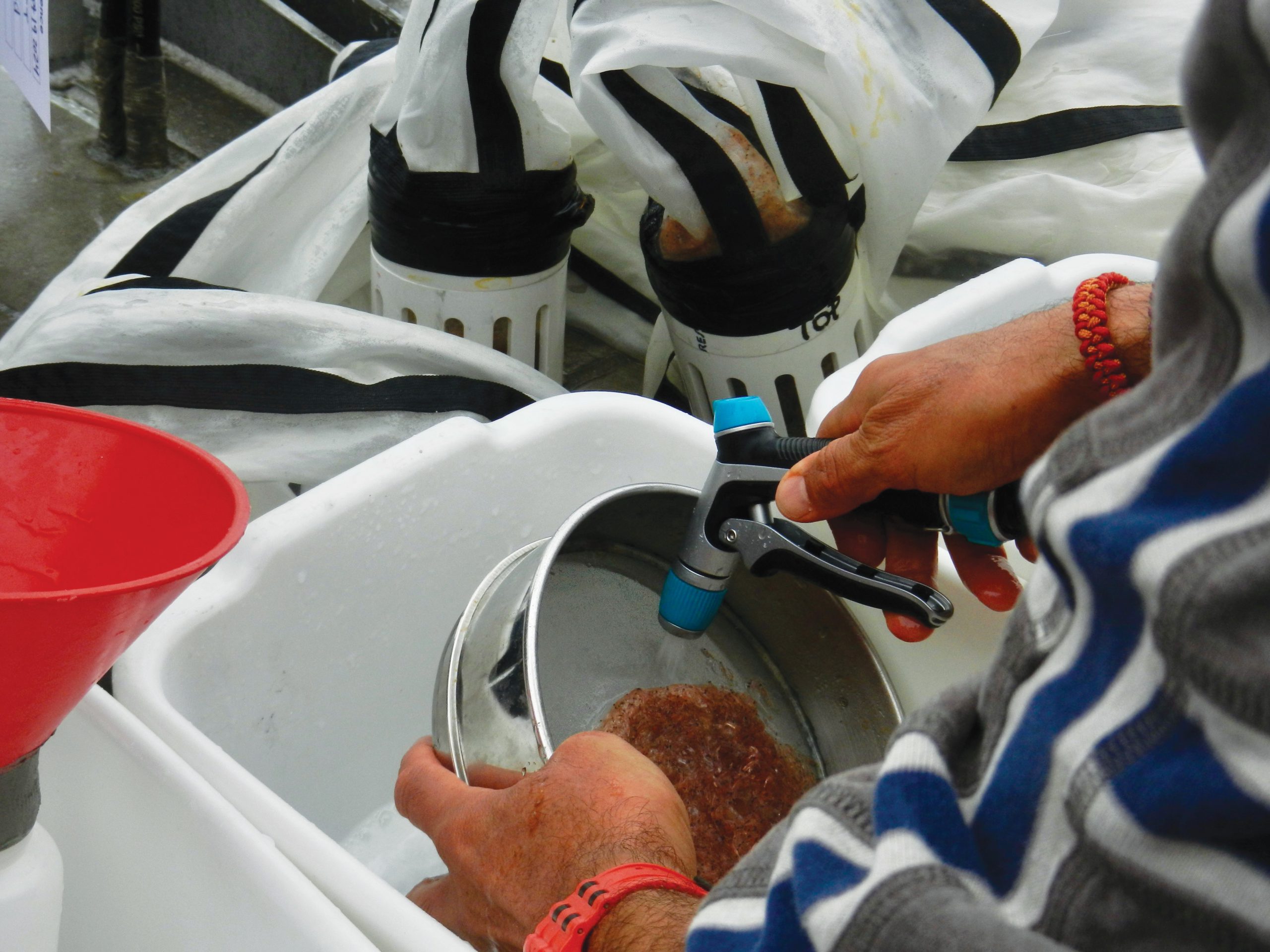
As the boat continued to move and sway with the current and the rocking of a small swell, the large net was removed and cleared. Another net was placed onto the winch line. This one was intended to drag behind the boat, gathering whatever plankton was floating about. After a short amount of time, they reeled in the line and brought the samples in, rinsed them and placed them into sample tubes.
As the day went on and sampling continued, some of the crew gathered at the top deck to count marine mammals as others counted and observed birds. While there was much mammal and fish activity around the boat prior to the observations, the sea almost seemed to go quiet when they started observing. Some even made a joke about it at the next stop. But, surely enough, they spotted some animals.
Roletto, who I sat beside, spotted a shark, a few fur seals and fin whales. At one point, the entire back of a blue whale rose some 200 feet from the front of the boat, and the sound of water cascaded down its massive sides. We all looked on with excitement at seeing the largest animal on the planet, some 70 feet long, in front of us.
It was incredible what we could witness, even with so much fog.
However, after taking too long at one of the sights, we had to head back to shore.
Back to the Land
As the ship headed in, I heard some crew talking about the news and the fear of a potential furlough due to a shutdown by the federal government. One of the crew members said if the government were to shut down, there goes their jobs. Luckily, a stopgap bill was recently passed that made sure this didn’t happen.
While we sat again at the table, Stock pointed out that finding funding is often challenging for this work. While NOAA Sanctuaries runs part of the program and provides finances to pay for the boat and crew, Point Blue is the organization collecting and analyzing all of this complex data. Since they are a privately funded organization, largely through donations, the challenges for the longevity of their work are often in a slightly tenuous space.
Due to its smaller budget, the ACCESS organization can only plan out its work year by year.
Because of this, Jahncke said he hopes they will have more consistent and better resources in the future.
At that time, Jahncke said, he wants “more predictable resources to be able to plan forward more than year by year, which is how we do it right now.”
“There are also a lot of other things that are used at the bigger programs like CalCOFI [California Cooperative Oceanic Fisheries Investigations] in Southern California, to improve the way they use the data. For example, there are tools to automatically sample their plankton, and then they use AI and machine learning to identify the critters that they find,” Jahncke said. “That will speed up our process so much.”
The ship slowly made its way to shore just as the sun was about to go down. When we got off the boat, the light in the sky appeared to be the same as when we first left the dock. We had been on the boat for just over 12 hours, and stepping back on land felt surreal. Someone joked that we were in a dream.
As we neared the parking lot, I asked one of the crew members what she would be doing that night.
“Take a shower. Eat some dinner. Go to sleep. Do it all again tomorrow” was the reply.
Almost every week from April to the end of September, this crew heads out to the open and roiling waters of the Pacific to gather data and insight from our oceans. As climate change poses a greater and greater risk to the ocean, as ocean acidification becomes a more significant threat to the lives of trillions of creatures that call the open ocean their home, this data is a critical instrument in understanding what is happening in our waters and, hopefully, how we can ensure these ecosystems are as safe as they can be in an increasingly uncertain future.”


Wonderful write up, I felt like I was there out on the water too. The experience of seeing a blue whale so close, just thrilling. These people are so focused and dedicated to ocean health, very inspiring.
Thank-you for the adventure and narrative!
Excellent insight and detailed information. Thank you! We’d like to do a Resilient Earth Radio show & podcast episode on this subject. Thank you for this well written article and all the contact information that you have shared.